Trip Planning & Practicalities
Check Roadworks and Closure Alerts Before a Motorbike Trip
On this page
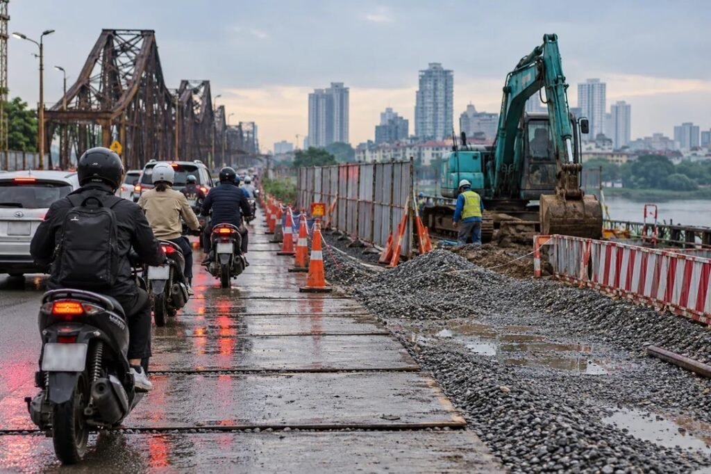
Checking roadworks and closure alerts before a motorbike trip from Hanoi means using official road-management notices, current weather warnings and the instructions displayed on the actual road—not relying on an old map screenshot or an unverified social post. A closure may affect one direction or vehicle class while another route remains usable. Landslide and flood conditions can change within hours. Before leaving, identify the authorities responsible for your intended roads, check the date and time of each announcement, then prepare a legal alternative or postpone the journey if necessary.
Why a route can change between planning and departure
Works to a junction, bridge, drainage system or road surface may close a lane or change a turn. A sporting event, public holiday or emergency can also lead to temporary traffic management. In mountainous areas, rain may cause landslides or damage a road that was open the previous day. Even a route normally suitable for motorbikes may have a section temporarily inaccessible.
Because authorities can issue new instructions, an alert published last month is not evidence that the same restrictions apply today. Conversely, a news headline saying “road reopened” may refer to one vehicle class or one lane rather than full normal traffic.
| Information needed | Useful place to check | What to read carefully |
|---|---|---|
| Hanoi street roadworks | Hanoi Department of Construction and relevant city notices | Road name, junction, affected directions, start and end dates |
| National road disruption | Vietnam Road Administration and its regional units | Kilometre markers, vehicle classes, restrictions and diversions |
| Flood and landslide risk | National Centre for Hydro-Meteorological Forecasting and disaster authorities | Issue time, areas at risk and validity period |
| Local road or bridge access | Local road managers and traffic police notices | On-site controls, one-way orders and temporary barriers |
| Current navigation estimate | A map application used as a supplement | Suggested roads must still be legal and open for motorbikes |
A single source rarely covers every road in a multi-province journey. Official city notices may cover construction in Hanoi but not a local mountain road far beyond city boundaries. Keep the route broken into segments so you know which authority’s information to look for.
Checking Hanoi roadworks announcements
The Hanoi Department of Construction publishes notices concerning traffic organisation around works, junctions and infrastructure projects. The notice may give a reference number, issue date, implementation window, direction of travel and restrictions. When the site includes a PDF attachment, try to read the actual announcement rather than relying only on its short webpage summary.
An example is the department’s July 2026 traffic-adjustment notice for work near the Vành đai 3.5–Thăng Long Boulevard junction. This illustrates what an official construction notice looks like. It does not prove the July restriction is still active on the day you read this article.
National roads and landslide reports
For routes extending into other provinces, check the Vietnam Road Administration’s reports and local road-manager information. A report may say a landslide location reopened in one lane, that heavy vehicles remain restricted or that another section is fully blocked. Read all the qualifying words. “Reopened” does not necessarily mean there are no remaining hazards.
The Road Administration has published updates on roads affected by flooding and landslides in northern Vietnam. Such historical reports are useful examples of how conditions evolve, not live status pages for an upcoming trip. Confirm the newest advisory before departure.
Weather alerts and road-closure notices are not interchangeable
A forecast warning about intense rain or landslide risk identifies an area where extra caution is warranted. It does not necessarily name the road that is already blocked. A road-management notice may identify an exact closed section without explaining the weather in a whole region. Read both when the journey enters flood-prone lowlands, hill roads or areas under heavy-rain warnings.
Vietnam’s national hydro-meteorological warning pages show issue times and areas affected by possible flash floods or landslides. A particular bulletin becomes historical as its validity period passes; look for the latest bulletin instead of assuming an old warning remains current.
How to read an alert in five minutes
- Confirm the source is genuinely an official road, local-government, police or weather channel.
- Find the publication and effective dates; some notices announce measures that start later.
- Read the exact road name, kilometre marker or intersection rather than only the province.
- Look for the direction and vehicle class affected; a restriction may be different for cars, buses and motorcycles.
- Check any PDF attachment, map or diversion diagram where available.
- Compare the notice with your exact route and current travel conditions.
- Save the useful details and decide on a lawful alternative or postponement.
Keep the phone safely stopped while checking the announcement. Do not attempt to read long notices or change navigation while riding.
A road open to cars may not be open to bikes
Traffic regulations and temporary diversions can apply different permissions to different vehicle categories. A report saying passenger cars may pass does not automatically grant motorcycles the same right. Similarly, a map suggesting an expressway does not mean motorbikes may enter it. Follow signs, barriers and traffic officers on the day.
Even if an old news item shows motorcycles being temporarily permitted on an unusual road during a particular emergency, do not assume that exception is permanent. Use the current traffic arrangement; avoid riding the wrong way on a service road or entering a prohibited high-speed carriageway.
A social post can alert you to a possible problem, but images may be old, geotagged incorrectly or shared without their original time. Treat the message as a prompt to verify. Look for a matching road-management or police notice, recent weather information and current updates for that exact location. Never publish an unconfirmed claim that a particular bridge collapsed or a road is safe to use.
When no reliable confirmation is available and the potential hazard is serious, a conservative alternative is to delay or avoid that section rather than using your trip to test the rumour.
Save essential information before leaving
If you travel through an area with unreliable mobile coverage, retain your planned route, a legal alternative, key contacts and the relevant official notice as available offline. Note the place where you can safely stop if conditions deteriorate. Offline information is a backup; it can become stale and must not override on-site signs.
Tell a trusted contact the intended route and approximate return time when appropriate. Avoid putting private identity documents in a public map or social-media group solely to share the journey.
When a closure occurs while you are on the road
Do not move cones, drive under a barrier or follow another vehicle into a restricted area. Slow and stop at a permitted safe location as directed, then ask an authorised officer or road manager about the permitted alternative if one exists. If the closure is due to a landslide, flood or unstable slope, avoid approaching the danger zone for a photograph.
Do not perform an illegal U-turn merely because a road is blocked ahead. Choose a lawful turning point, or follow the official diversion. If there is no safe route for the bike, stop the journey and arrange alternative transport as needed.
Road conditions and rental-provider permission are separate
Even if a national road is currently open, the rental shop may not authorise that route for a specific motorbike. Ask Nguyen Ha about the intended province, route, duration, mileage and breakdown contact before setting off. Conversely, permission under a rental agreement does not mean you may ignore a road closure, hazard or traffic restriction.
Read the Vietnamese guide to roadworks, restrictions and landslides before long trips for the original discussion of local sources. Check updated notices near departure because a road’s status can change rapidly.
Putting the checks into a departure-day routine
| When | What to do |
|---|---|
| Several days ahead | Outline the trip, legal road classes and available alternate routes |
| Day before | Read traffic and weather alerts, confirm rental permission |
| Before departure | Refresh official notices and weather, check the actual bike |
| At an unexpected barrier | Stop safely, follow traffic-control instructions and reassess |
| When a warning escalates | Delay or cancel rather than forcing an unsafe route |
Message to the rental provider
Hello Nguyen Ha, I plan to take a rental motorbike from Hanoi to [destination] on [dates] via [route]. I am checking current roadworks and weather warnings. Is this trip permitted for the actual bike, and are there any contract restrictions or arrangements for reporting a breakdown? If my route becomes closed, what should I do about the agreed return date and the vehicle’s safe parking?
Frequently asked questions
Does a map app show every road closure accurately?
No. Use map estimates as support and follow official road notices and instructions on site.
Can I ride through a closure if the road looks clear?
No. A barrier or official restriction may concern an unseen hazard. Follow the traffic-control directions.
Does an old report saying a road reopened prove it is open now?
No. Confirm the date, vehicle class and current notice before relying on it.
Nguyen Ha Motorbike Rental: Ngõ 5 Nguyễn Văn Cừ, Bồ Đề, Long Biên, Hanoi, Vietnam; 09:00–21:00. Phone +84 334 699 969.